Join our mailing list and receive invitations to our events and updates on our research in your inbox.
Taking as its point of departure Ian McHarg's landmark book Design With Nature (1969), Design With Nature Now surveys 25 dynamic and visionary approaches to landscape architecture around the world, takes visitors to McHarg's Glasgow in a series of abstract meditations on place and time, and traces the development of his ecological approach to design.
Design With Nature Now: Five Themes, 25 Projects
Meyerson Hall Lower Gallery
June 21–September 15
Gallery Hours: Tuesday through Friday, 10:00am to 5:00pm; Saturday 12:00 to 5:00pm.
Urban Futures
Willamette River Basin
Oregon, USA
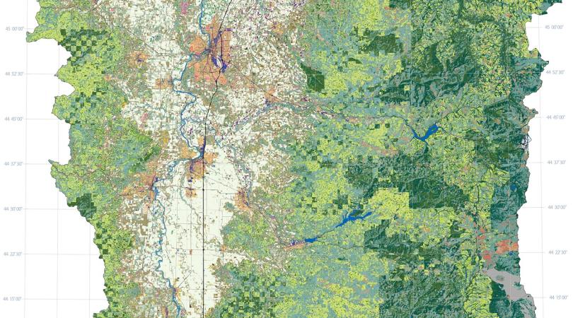
<p>In 1996 the U.S. Environmental Protection Agency (EPA) initiated a five-year scientific research effort to support community-based environmental planning. Because citizen groups in the Willamette River Basin (WRB) in Oregon were already attempting to address complex environmental issues, the EPA selected the WRB as one of its focal areas for the initiative. The EPA formed the Pacific Northwest Ecosystem Research Consortium, which consisted of thirty-four scientists at ten different institutions. The consortium’s studies were focused on accommodating growth while preserving natural resources. Outcomes of this research have resulted in land acquisition (through fee-simple purchase and conservation easements) and on-the-ground restoration of floodplain forest and channel reconnections. These initiatives have led to a decrease in the water temperature, an increase in fish species richness and riparian forest, and a reduction in invasive plant cover.</p>
Dave Hulse
Stan Gregory
Joan Baker
Allan Branscomb
Chris Enright
David Diethelm
Dixon Landers
Linda Ashkenas
Doug Oetter
Paula Minear
Randy Wildman
Kelly Wildman
John Christy
Mieko Aoki
Warren Cohen
With funding from the U.S. Environmental Protection Agency, Oregon State University, and the University of Oregon.
Envision UTAH
USA
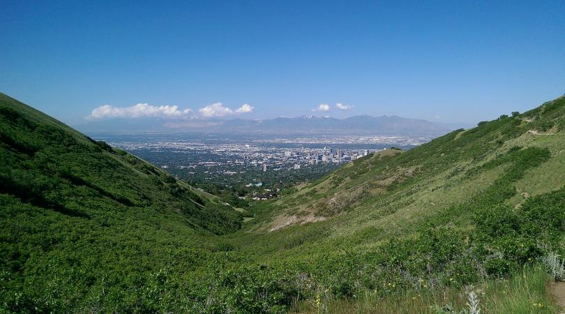
<p>The population of the Salt Lake City region in Utah is expected to reach 2.7 million by 2020—over a million more residents than in 1995, the year Envision Utah began. Five million residents are projected to live in the region by the year 2050. The region’s growth and developable land are bound, in large part, by a series of natural features—the Wasatch Mountain Range, the Great Salt Lake, Utah Lake, surrounding desert, and federally owned land. A diverse group of community leaders from business and government came together to form Envision Utah, a nonprofit organization committed to facilitating bottom-up, nonpartisan, collaborative decision-making processes to help Utahns plan. Envision Utah organized a series of workshops to broaden people’s understanding of the existing trends and challenges and enable stakeholders to develop four alternative future visions with planner consultants. This was a pioneering approach, and Envision Utah continues to plan for growth with continuing initiatives.</p>
During the initial planning for Envision Utah, Calthorpe Associates Urban Designers, Planners, Architects with Fregonese Calthorpe Associates and QGET (Quality Growth Efficiency Tools Technical Committee) generated key scenario planning studies. Further developments can be found here: www.envisionutah.org and yourutahyourfuture.org
Medellín
Colombia
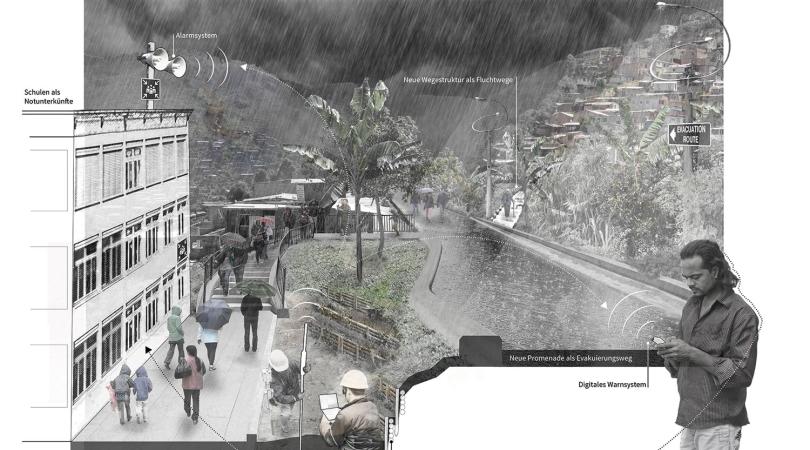
<p>The city of Medellín suffers from extreme inequality that is reflected in its housing types and the broader built environment within the city’s valley section. The wealthy tend to live in central, well-serviced enclaves, while the poor live on peripheral steep slopes in self-constructed settlements. Since 2003, the city has undergone an internationally recognized urban transformation, coinciding with a restoration of peace in what was once the most dangerous city in the world. Medellín began rapidly linking what it identified as “nodes of development” in some of the city’s poorest neighborhoods—libraries, schools, and public spaces—to public transportation. These projects are an outgrowth of a philosophical and practical shift in planning was first described in the city’s Plan de Ordenamiento Territorrial of 1998, a document that built on existing United Nations efforts to provide basic services to the informal communities,or comunas, on the urban periphery. Though Medellín successfully provided services to informal settlements on its periphery, the question of how informal settlements arise in the first place and whether their growth can be planned is also relevant. The BIO 2030 Plan addresses this larger issue by documenting the geology, hydrology, ecology, and fragmentation of the entire Aburrá Valley, then providing designs for different developments using the layers of physical information as a base. Professors of landscape architecture and urban design David Gouverneur and Christian Werthmann, among others, are developing projects with students related to the social, ecological, and political challenges of designing informal settlements. This work continues in Medellín and other areas.</p>
16.2 Medellín
Plan Director Medellín, Valle de Aburrá. Un sueño que juntos podemos alcanzar. Medellín: Alcaldía de Medellín, Área Metropolitana del Valle de Aburrá and Urbam EAFIT, http://www.eafit.edu.co/centros/urbam/articulos-publicaciones/SiteAsset….
Medellin River Parks (Parques del Rio): Architectural design: Sebastián Monsalve, Juan David Hoyos. Design team: Osman Marín, Luis Alejandro Jiménez, Andrés Santiago Fajardo, Sebastián González, Juan Diego Martínez, Maria Clara Trujillo, Alejandro Vargas, Carolina Zuluaga, Daniel Zuluaga, Sara París, Daniel Beltrán, Daniel Felipe Zuluaga, David Castañeda, Alejandro López, David Mesa, Andrés Velásquez, Juan Camilo Solís, Melissa Ortega, D. David Hernández del Valle. Landscape design: Nicolás Hermelín. Photography: Alejandro Arango Escobar, Sebastián González Bolívar. Engineering team: Consorcio EDL. Builder team: Guinovart Obras y Servicios Hispania S.A. Grupo OHL Construcción. Construction supervision team: El Consorcio integral – Interdiseños. Design audit team: Bateman Ingeniería S.A. Medellín’s town hall: Aníbal Gaviria. Director of Administrative Department of Planeación de Medellín: Jorge Alberto Pérez Jaramillo. Management of Medellín River Parks: Antonio Vargas del Valle.
Shifting Ground / Medellín
Project Team
Intitute of Landscape Architecture, Leibniz Universität Hannover: Christian Werthmann, Joseph Claghorn, Nicholas Bonard, Florian Depenbrock, Mariam Farhat;
Centro de Estudios Urbanos y Ambientales (urbam) / LA Universidad EAFIT (Escuela de Administración, Finanzas e Instituto Tecnológico): Alejandro Echeverri, Francesco María Orsini, Juan Sebastian Bustamante Fernández, Ana Elvira Vélez Villa, Isabel Basombrío, Diana Marcela Rincón Buitrago, Juan Pablo Ospina, Anna Manea, Daniela Duque, Ángela Duque, Simón Abad, Lina Rojas, Maya Ward-Karet, Santiago Orbea Cevallos;
Harvard Graduate School of Design: Aisling O’Carroll, Conor O’Shea
Contracting authority
Municipal Planning Authority of the City of Medellín
Cooperation partners
Fundacíon CIPAV, Fundación Sumapaz, Aníbal Gaviria Correa, Jorge Pérez Jaramillo, Juan Manuel Patiño M., Paola Andrea López P., Sergio Mario Jaramillo V., David Emilio Restrepo C., Mario Flores, John Cuartas, María Alejandra Rodríguez N.
Participating project specialist
Eva Hacker / soil bioengineering, Marco Gamboa / geology, Michel Hermelin / geology, Iván Rendon / sociology, Tatiana Zuluaga / urban planning
Barcelona Metro Region
Catalonia, Spain
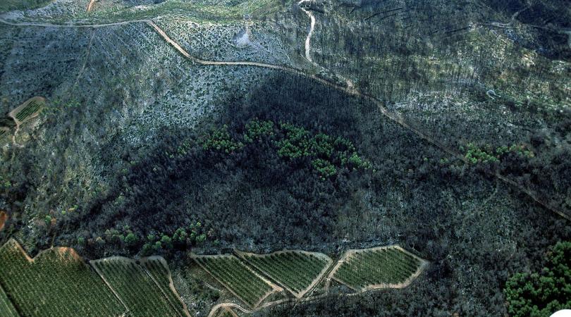
<p>Like many metropolitan areas, the Barcelona region faces challenges of urban growth, degrading natural land, shrinking farmland, insufficient and contaminated water, traffic congestion, and climate change. In 2002, Harvard landscape ecologist Richard T. T. Forman completed his plan, Land Mosaic for the Metropolitan Region of Barcelona (published in Spanish in 2004 as Mosaico territorial para la region metropolitana de Barcelona). The project’s objective was to envision solutions and outline spatial arrangements to enhance natural systems and associated human land uses for the long-term future of the greater Barcelona region. Six years later the Catalan government completed its regional plan, Pla territorial metropolita de Barcelona, which incorporated many concepts from Forman’s plan. His land mosaic plan also led to Forman’s book Urban Regions, a delineation and analysis of small-to-large urban regions (including the Barcelona model) on all inhabited continents.</p>
Mosaico territorial para la region metropolitana de Barcelona
The urban regional plan for Barcelona was produced for Mayor Joan Clos and Chief Architect Josep Acebillo by Harvard University Professor Richard T. T. Forman and his Barcelona team of Sito Alarcon, Marc Montlleo, Xavier Mayor, and Eva Serra. Preliminary meetings occurred in November 2000 and April 2001, the plan was developed and completed in 15 months (June 2001 to September 2002), and the product translated and published as Forman, R. T. T. (2004). Mosaico territorial para la region metropolitana de Barcelona, R. T. R. Forman, (2004, Barcelon: Gustavo Gili).
Pla territorial metropolita de Barcelona
This 2010 plan was produced by Generalitat de Catalunya, Departament de Politica Territorial i Obres Públiques.
Qianhai Water City
Shenzhen, China
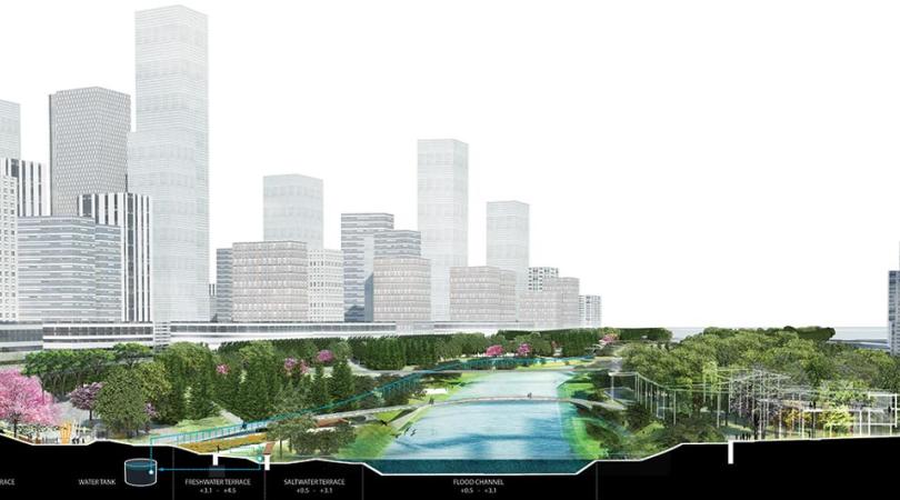
<p>Qianhai Bay is located in the Pearl River Delta, west of Shenzhen on the shore of the South China Sea. This area is a key point in the Pearl River estuary at the crossing of the east-west axis of Shenzhen and the north-south axis of Guangzhou to Hong Kong. Officially approved by China’s State Council in 2010, the Qianhai Shenzhen–Hong Kong Modern Service Industry Cooperation Zone was established to serve as a pilot business zone for closer cooperation between Mainland China and Hong Kong in the financial, logistics, and information technology services sectors. In 2009, James Corner Field Operations (JCFO) won the international competition to develop the master plan for Qianhai Water City. Over an area of 4,500 acres (1,822 hectares) of landfill, the master plan is defined by so called “water fingers.” The water fingers are linear parks designed to collect, retain, filter, and cleanse stormwater in a series of terraces and ponds. Widened and extended from the existing water tributaries, these linear parks define the main zones of public space and delimit future urbanization. When all the fingers are completed, they will provide the public with large linear parks accessible by foot from the center of each district. Guiwan Park is the first water finger to be built. With an opening anticipated in 2021, the park’s design naturalizes an existing tidal channel to create various water’s edge habitats within continuous sculpted topography.
</p>
Qianhai Water City post-competition design and planning phases
Client: Authority of Qianhai Shenzhen-Hongkong Modern Service Industry Cooperation Zone of Shenzhen
Team: James Corner Field Operations, Zhubo Design Group Co. Ltd., Buro Happold International (Hong Kong) Limited, Tsinghua Urban Planning and Design Institute, The Pearl River Hydraulic Research Institute
Guiwan Water Finger Park Design:
Client: Shenzhen Qianhai Development Investment Holdings Co., Ltd.
Team: James Corner Field Operations, Shanghai Landscape Design and Research Institute
Laurel McSherry: A Book of Days
Arthur Ross Gallery, Housed in the Fisher Fine Arts Library Building
June 21–September 15
Gallery Hours: Tuesday, Thursday, and Friday 10:00am to 5:00pm; Wednesday 10:00am to 7:00pm; Saturday and Sunday 12:00 to 5:00pm.
-
 Credit: Laurel McSherry
 -
 Credit: Laurel McSherry
 -
 Credit: Laurel McSherry
 -
 Credit: Laurel McSherry
Laurel McSherry: A Book of Days is conceived to inspire visitors to think about their everyday landscapes in new and thoughtful ways. Presented at and in collaboration with Penn’s Arthur Ross Gallery, this site-specific installation by landscape architect and visual artist Laurel McSherry, takes as its subject the Clyde River Valley in Scotland, McHarg’s childhood home. McHarg’s experiences in the landscapes there inform the very personal narrative which is central to Design With Nature. A Book of Days brings that experience to life through a series of installations using the mediums of video, etchings, and sculpture.
Ian McHarg: The House We Live In
Kroiz Gallery, Architectural Archives
June 21–September 15
Gallery Hours: Tuesday through Friday, 10:00am to 5:00pm; Saturday 12:00 to 5:00pm.
-
 Credit: Architectural Archives of the University of Pennsylvania
 -
 Credit: Architectural Archives of the University of Pennsylvania
Ian McHarg: The House We Live In, presented in the Kroiz Gallery (located across a public plaza from the Meyerson Galleries in the Fisher Fine Arts Library building), draws from extensive archival holdings in the School's Architectural Archives to locate the foundations of Design With Nature in the 1950s and challenge some critics’ perception that McHarg was uninterested in design and aloof to the subtleties of human experience. It brings a new emphasis to his early teaching, the activism it inspired among his students and followers, and the tools he created to redefine the parameters of design to be more attuned to the natural processes that form our ever-changing landscapes.
Support
Design With Nature Now
exhibitions have been
supported by The Pew Center
for Arts & Heritage.