Join our mailing list and receive invitations to our events and updates on our research in your inbox.
Taking as its point of departure Ian McHarg's landmark book Design With Nature (1969), Design With Nature Now surveys 25 dynamic and visionary approaches to landscape architecture around the world, takes visitors to McHarg's Glasgow in a series of abstract meditations on place and time, and traces the development of his ecological approach to design.
Design With Nature Now: Five Themes, 25 Projects
Meyerson Hall Lower Gallery
June 21–September 15
Gallery Hours: Tuesday through Friday, 10:00am to 5:00pm; Saturday 12:00 to 5:00pm.
Big Wilds
Yellowstone to Yukon Conservation Initiative
USA and Canada
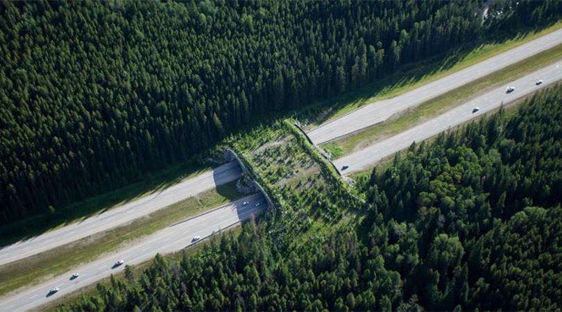
<p>In 1993, lawyer and conservationist Harvey Locke first proposed a continuous corridor of protected habitat from Yellowstone National Park in the United States to the Yukon in Canada. Four years later, the Yellowstone to Yukon Conservation Initiative (Y2Y) was founded, and its plan is now being implemented. The Y2Y corridor spans nearly 2,000 miles (3,200 kilometers) and encompasses over 500,000 square miles (1.3 million square kilometers) of land. Inspiration for Y2Y is traced to a female wolf named Pluie, who was tracked with a GPS collar migrating from Canada’s Banff National Park to America’s Glacier National Park to near Spokane, Washington over an eighteen month period. This journey was testament to the wolf’s stealth and cunning and also suggested the need for continuous corridors of wildlands to allow other species to migrate throughout the territory in relative safety.</p>
The Yellowstone to Yukon Conservation Initiative is a joint Canada-U.S. not-for-profit organization dedicated to securing the long-term ecological health of the region. Information about its projects can be found at https://www.y2y.net/
Malpai Borderlands
Arizona and New Mexico, USA
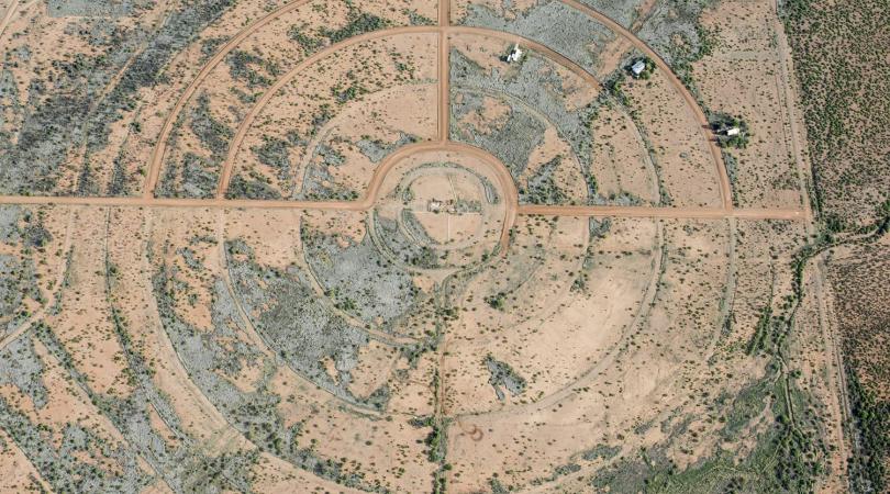
<p>In the boot of New Mexico and the southeastern tip of Arizona along the U.S.-Mexico border, there is a 1,250 square mile (3237.5 square kilometer) plot of land, almost entirely unbroken by highways or subdivisions. The Malpai Borderlands harbors an estimated 4,000 species of plants, 104 species of mammals, 327 species of birds, 136 species of reptiles and amphibians, and the greatest diversity of bee species in the world. In this biodiverse landscape, 53 percent of the area is privately owned and 47 percent is public—a split that has led to tensions between government agencies, cattle ranchers, and environmentalists. The success of the Malpai Borderlands Group can be credited both to their reliance on science to help manage the Malpai and to their commitment to educating others about how grazing and conservation can coexist.</p>
The Malpai Borderlands Group (http://www.malpaiborderlandsgroup.org/) is a nonprofit organization comprised of landowners whose mission is to manage the ecosystem of nearly one million acres of relatively un-fragmented landscape.
Great Green Wall
Africa
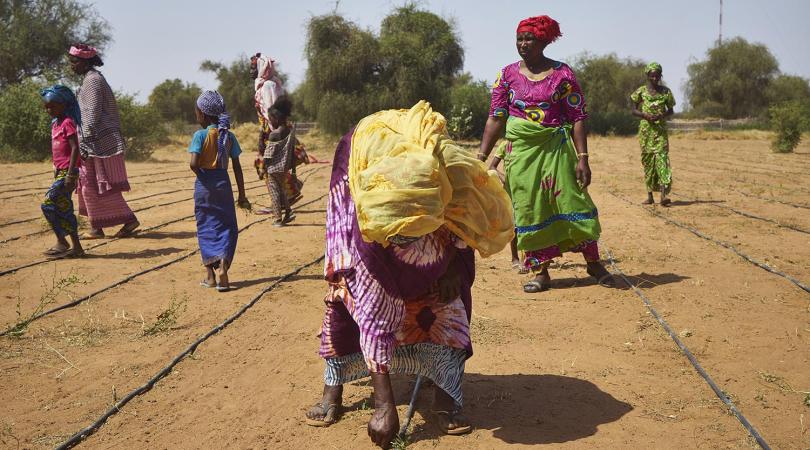
<p>Formally known as the Great Green Wall of the Sahara and Sahel Initiative (GGWSSI), the Great Green Wall spans approximately 8,000 kilometers (4,970 miles) from Senegal to Djibouti and is 15 kilometers (9 miles) deep. Its purpose is to combat desertification by restoring degraded lands on the front lines of the encroaching desert. The idea of a wall of trees at the edge of the Sahara and the semi-arid belt of the Sahel is not a new one; it was originally proposed as early as the 1950s. However, it was not until 2007 that the governments of the twenty nations that encompass the wall endorsed the idea and began to undertake the project. Since 2007 the GGWSSI mission has evolved to encompass native bushes and grasses, as well as farmer-driven agricultural technologies like agroforestry and 'zai' pits to increase the moisture and fertility of the soil. When it is complete in 2030, it will be the largest designed living structure in the world.</p>
The Great Green Wall is an initiative supported by United Nations Convention to Combat Desertification. Partners include: Permanent Inter-State Committee for Drought Control in the Sahel (CILSS), European Union (EU), Food and Agriculture Organization of the United Nations (FAO), Global Environment Facility (GEF), United Nations Convention to Combat Desertification (UNCCD), International Union for Conservation of Nature (IUCN-PACO), Sahara and Sahel Observatory (OSS), and the World Bank Group (WBG).
National Ecological Security Pattern Plan
China
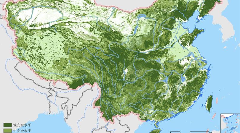
<p>Between 2006 and 2008, Kongjian Yu, founding principal of the design firm Turenscape, led a research planning exercise on behalf of the Chinese Ministry of Environmental Protection and the Chinese Ministry of Cultural Protection. The project—translated into English as National Ecological Security Pattern Plan (NESP)—was to develop geospatial plans on a national scale that indicated where the “ecological security” (i.e. ecological health) of land should be prioritized. The plans were to address issues such as water catchment protection, flood control, desertification, soil erosion, and biodiversity conservation. This research represents an emerging recognition at the highest levels of government that ecological concerns are in the Chinese economic interest and should be reflected in Chinese land use planning guidelines.</p>
Kongjian Yu, Dihua Li, Zhifang Wang, Liyan Xu, Xili Han, Hailong Liu, Lei Zhang, Xuesong Xi, Sisi Wang, Hailong Li, Bo Li, and Bo Luan
Landscape Regeneration of Western Waiheke Island
New Zealand
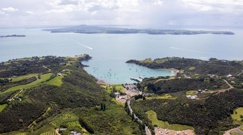
<p>Although New Zealand enjoys worldwide fame as “clean and green,” the reality is different. New Zealand has suffered massive deforestation and huge loss of unique biodiversity over the past 300–400 years. More than half of the country’s farming landscape is damaged and deteriorating and requires regenerative action. Some New Zealanders have taken such action in the western area of Waiheke Island, on the periphery of Auckland, the nation’s largest metropolitan area. The Western Waiheke project is a composite of five master plans for individual private land owner clients who initially wanted lifestyle property subdivisions. Using McHargian land suitability analysis, the design team identified and mapped areas of land that have critical sensitivity, as well as cultural features and used them as the basis for an interconnected “landscape commons,” of indigenous vegetated habitat.</p>
Foundation Project – Auckland Council District Plan, Hauraki Gulf Islands Section:
Prepared for Auckland City Council by the Auckland Council Maritime and Rural Planning Team; Barry Kaye, Neil Rasmussen, Matthew Feary, and Jane Jennings in association with D. J. Scott Associates Ltd, Landscape Architects and A. B. Matthews & Associates, Surveyors and Planners.
Project 1 – Church Bay and Project 2 – Bush Landscape Lot, Western Waiheke Island:
Prepared for Nick and Annette Johnstone by D. J. Scott Associates Ltd, Landscape Architects in association with Beca, Carter, Hollings and Ferner; Engineers and Planners.
Project 3 - Park Point and Project 4 – Cable Bay:
Prepared for Walter and Kerry Titchener by D. J. Scott Associates; Landscape Architects & A. B. Matthews & Associates, Surveyors and Planners in association with TSE Group Ltd, Engineers.
Project 5 - Owhanake:
Prepared for Waiheke Island Coastal Estates Ltd by D. J. Scott Associates Ltd, Landscape Architects and Resource Planners in association with TSE Group Ltd, Engineers.
The D.J. Scott Associates Ltd Landscape Architecture and Planning team included Dennis Scott, Logan Anderson, Megan Moors, Glen May, Grant Kneebone, and Scott Cameron.
Other prominent team members included Charles Mitchell Associates Ltd, Ecology; Architage Ltd and Rod Clough Associates, Archaeology; Babbage Consultants Ltd, Geotechnical Engineers; and Traffic Design Group Ltd, Traffic Engineers.
Primary Project Implementation Contractors:
Waiheke Contractors Ltd, Civil Contractors; Awarua Nurseries, Green Input and Rural Design, Revegetation/Planting Contractors.
Samboja Lestari
East Kalimantan (Borneo), Indonesia
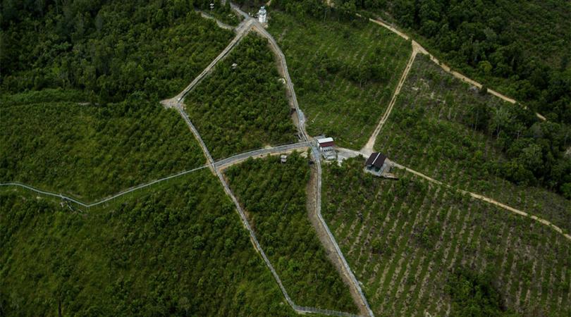
<p>Over the past half-century, East Kalimantan, the Indonesian portion of the island of Borneo, has experienced rapid deterioration of its landscape. Owing to a burgeoning population and clear-cutting of its rainforest for Agricultural land, timber, and palm oil, roughly half of the rainforest has been razed. With the loss of habitat the orangutan cannot find food and faces starvation or capture. Orangutans that raid agricultural lands are considered pests and are often killed. In an effort to reconstruct a viable rainforest ecosystem and contribute to the local economy, the Samboja Lestari afforestation project was founded in 2001 by Dr. Willie Smits and the Borneo Orangutan Survival Foundation. The original aim was for Samboja Lestari to sustain 1,000 orangutans as a breeding population large enough to survive in the event that all other orangutans were wiped out. The plan was to plant more fruiting species within Samboja Lestari than would be found in a typical rainforest so as to feed the orangutans. In addition, the local residents would be given free land outside the belt of sugar palms to farm using agroforestry techniques.</p>
Samboja Lestari afforestation project (1991): Dr. Willie Smits and the Borneo Orangutan Survival (BOS) Foundation. The BOS Foundation has expanded its work to other areas of Indonesia and is a non-profit whose mission is “to conserve the Bornean orangutan and its habitat, in cooperation with local communities, the Indonesian Ministry of Forestry, and international partner organizations.”
Laurel McSherry: A Book of Days
Arthur Ross Gallery, Housed in the Fisher Fine Arts Library Building
June 21–September 15
Gallery Hours: Tuesday, Thursday, and Friday 10:00am to 5:00pm; Wednesday 10:00am to 7:00pm; Saturday and Sunday 12:00 to 5:00pm.
-
 Credit: Laurel McSherry
 -
 Credit: Laurel McSherry
 -
 Credit: Laurel McSherry
 -
 Credit: Laurel McSherry
Laurel McSherry: A Book of Days is conceived to inspire visitors to think about their everyday landscapes in new and thoughtful ways. Presented at and in collaboration with Penn’s Arthur Ross Gallery, this site-specific installation by landscape architect and visual artist Laurel McSherry, takes as its subject the Clyde River Valley in Scotland, McHarg’s childhood home. McHarg’s experiences in the landscapes there inform the very personal narrative which is central to Design With Nature. A Book of Days brings that experience to life through a series of installations using the mediums of video, etchings, and sculpture.
Ian McHarg: The House We Live In
Kroiz Gallery, Architectural Archives
June 21–September 15
Gallery Hours: Tuesday through Friday, 10:00am to 5:00pm; Saturday 12:00 to 5:00pm.
-
 Credit: Architectural Archives of the University of Pennsylvania
 -
 Credit: Architectural Archives of the University of Pennsylvania
Ian McHarg: The House We Live In, presented in the Kroiz Gallery (located across a public plaza from the Meyerson Galleries in the Fisher Fine Arts Library building), draws from extensive archival holdings in the School's Architectural Archives to locate the foundations of Design With Nature in the 1950s and challenge some critics’ perception that McHarg was uninterested in design and aloof to the subtleties of human experience. It brings a new emphasis to his early teaching, the activism it inspired among his students and followers, and the tools he created to redefine the parameters of design to be more attuned to the natural processes that form our ever-changing landscapes.
Support
Design With Nature Now
exhibitions have been
supported by The Pew Center
for Arts & Heritage.