Join our mailing list and receive invitations to our events and updates on our research in your inbox.
News + Events
Test
Test
Test
Test
Test
Test
Test
Test
Test
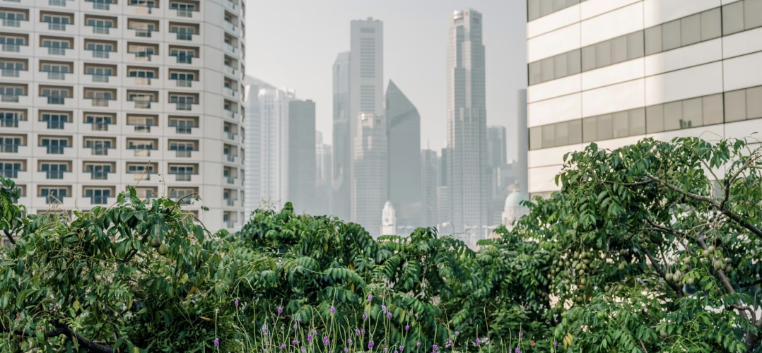
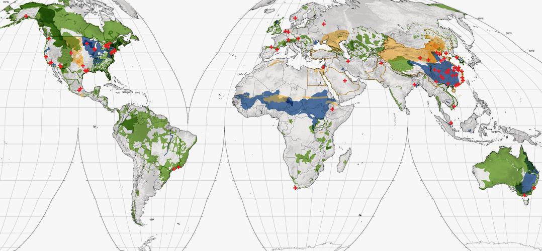
Denser and greener cities: Green interventions to achieve both urban density and nature.
- Green spaces in urban areas—like remnant habitat, parks, constructed wetlands, and street trees—supply multiple benefits.
- Many studies show green spaces in and near urban areas play important roles harbouring biodiversity and promoting human well-being. On the other hand, evidence suggests that greater human population density enables compact, low-carbon cities that spare habitat conversion at the fringes of expanding urban areas, while also allowing more walkable and livable cities. How then can urban areas have abundant green spaces as well as density?
- In this paper, we review the empirical evidence for the relationships between urban density, nature, and sustainability. We also present a quantitative analysis of data on urban tree canopy cover and open space for United States large urbanized areas, as well as an analysis of non-US Functional Urban Areas in OECD countries.
- We found that there is a negative correlation between population density and these green spaces. For Functional Urban Areas in the OECD, a 10% increase in density is associated with a 2.9% decline in tree cover. We argue that there are competing trade-offs between the benefits of density for sustainability and the benefits of nature for human well-being. Planners must decide an appropriate density by choosing where to be on this trade-off curve, taking into account city-specific urban planning goals and context.
- However, while the negative correlation between population density and tree cover is modest at the level of US urbanized areas (R2 = 0.22), it is weak at the US Census block level (R2 = 0.05), showing that there are significant brightspots, neighbourhoods that manage to have more tree canopy than would be expected based upon their level of density. We then describe techniques for how urban planners and designers can create more brightspots, identifying a typology of urban forms and listing green interventions appropriate for each form. We also analyse policies that enable these green interventions illustrating them with the case studies of Curitiba and Singapore.
- We conclude that while there are tensions between density and urban green spaces, an urban world that is both green and dense is possible, if society chooses to take advantage of the available green interventions and create it.
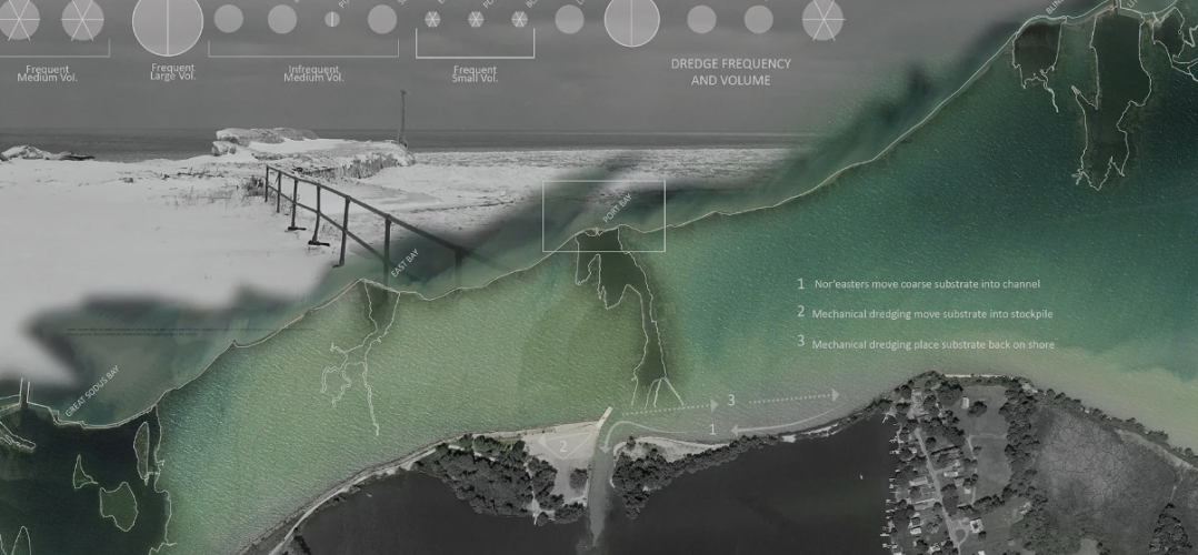
Developing and monitoring an innovative NNBF to nourish a bay bar: An example from the southeast shore of Lake Ontario
This project tests a cost-effective, innovative dredged sediment placement technique targeted to nourish an eroded barrier bar. The dredged sediment was placed in the nearshore in a Cobble Bell, a form designed to allow for efficient dispersal and migration of sediment by natural processes in this location (such as predominant waves and longshore transport) in a desired direction along the bar. We describe the regional and site assessment undertaken, and explain the way design parameters including technical feasibility, assumptions about wave climate, and constructability were accounted for. A monitoring protocol was designed and implemented to measure the vertical and horizontal accretion on the barrier bar. This included survey transects using RTK equipment and surface analysis of beach volume and morphology change via drone images and photogrammetry. Field measurements of the bar indicated that within the first few days, the piled material eroded rapidly, and over the next few months, migrated downshore, widening the previously breached area. This suggests that the cobble bell nature-based feature has the potential to both accelerate and slow down natural processes in ways that enhance the performance and attractiveness of the beach while minimizing costs. In addition to the monitoring results, we describe a monitoring protocol that is both simple and effective which can be adapted by local entities interested in the management of their coastal landscapes.
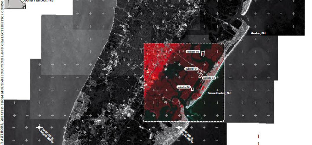
Behind-the-Scenes: Multispectral imagery and land cover classification
This article focuses on the use of remotely sensed multispectral imagery for land cover classification, a process that landscape architects may know little about but that underpins many of the maps that they use as the basis for their designs. The relatively arbitrary nature of classification, and the homogenization that occurs when classifying multispectral imagery to create land cover maps, is especially consequential when distinguishing between land and water. Yet ‘finding’ water is a key step in land cover classification. The salt marshes surrounding the Wetlands Institute in Stone Harbor, New Jersey, USA are used as a case study for multispectral analysis that combines satellite imagery with on-site surveying. However, the implications of the digital survey methods extend beyond any particular site and point to broader questions about the role of image interpretation for understanding how landscapes and environments are changing, especially with growing uncertainty about the rate of climate change.